What is geodesy?
Geodesy is the science of accurately measuring and understanding Earth's geometric shape, orientation in space, and gravity field. It is a critical field that enables us to make accurate maps and to understand and monitor movements of the Earth's crust. This information is used in a variety of fields, including surveying, engineering, and navigation. Geodesists (scientists working in the field of geodesy) use sophisticated equipment and techniques to make precise measurements of Earth's size, shape, and gravity field, and to monitor changes in these characteristics over time.
Measuring Earth's deformation
Geodesists use a variety of techniques to measure deformations in the Earth's surface, such as satellite radar interferometry, Global Navigation Satellite Systems (GNSS), and ground-based strain meters. Satellite radar interferometry involves using radar images from satellites to measure very small changes in the distance between the satellite and the Earth's surface, which can be caused by movements of the Earth's crust. GNSS involves using a network of satellites to measure the precise location of points on the Earth's surface, which can be used to track changes in the Earth's shape over time. Ground-based strain meters are instruments that are placed on or near the Earth's surface to measure very small deformations, such as those caused by earthquakes.
Global Navigation Satellite Systems (GNSS), the most famous of which being the Global Position System (GPS), are one of the most commonly used means of measuring Earth deformation, due to the relatively low power and cheap electronics used to build ground receivers. GPS was initially developed as a military navigation system, but can now be accessed by anyone on devices such as a smart phone. A constellation of satellites broadcast ultra-precise clock times via carrier signals in the microwave frequency band (typically ~1.6 and ~1.2 GHz, known as the L1 and L2 bands, respectively). Ground receivers, which also contain a clock, compare the broadcast timestamps to the times at which they were received and (assuming the two clocks are synchronised) calculate a range from the receiver to the satellite. By calculating the range to a number of satellites, these ground receivers can estimate their position with a great deal of accuracy. Phase information can also be incorporated to produce the ultra-high precision measurements that are typically required for the study of surface deformation. Ephemerides for the GPS satellites—that is, tables of the exact orbital positions and other state-of-health information—are published regularly and must be accounted for when calculating the positions of the ground receivers. Other GNSS systems include the Galileo system (European Union), GLONASS (Russia), BeiDou (China), IRNSS (India), and the Quasi-Zenith Satellite System (Japan).
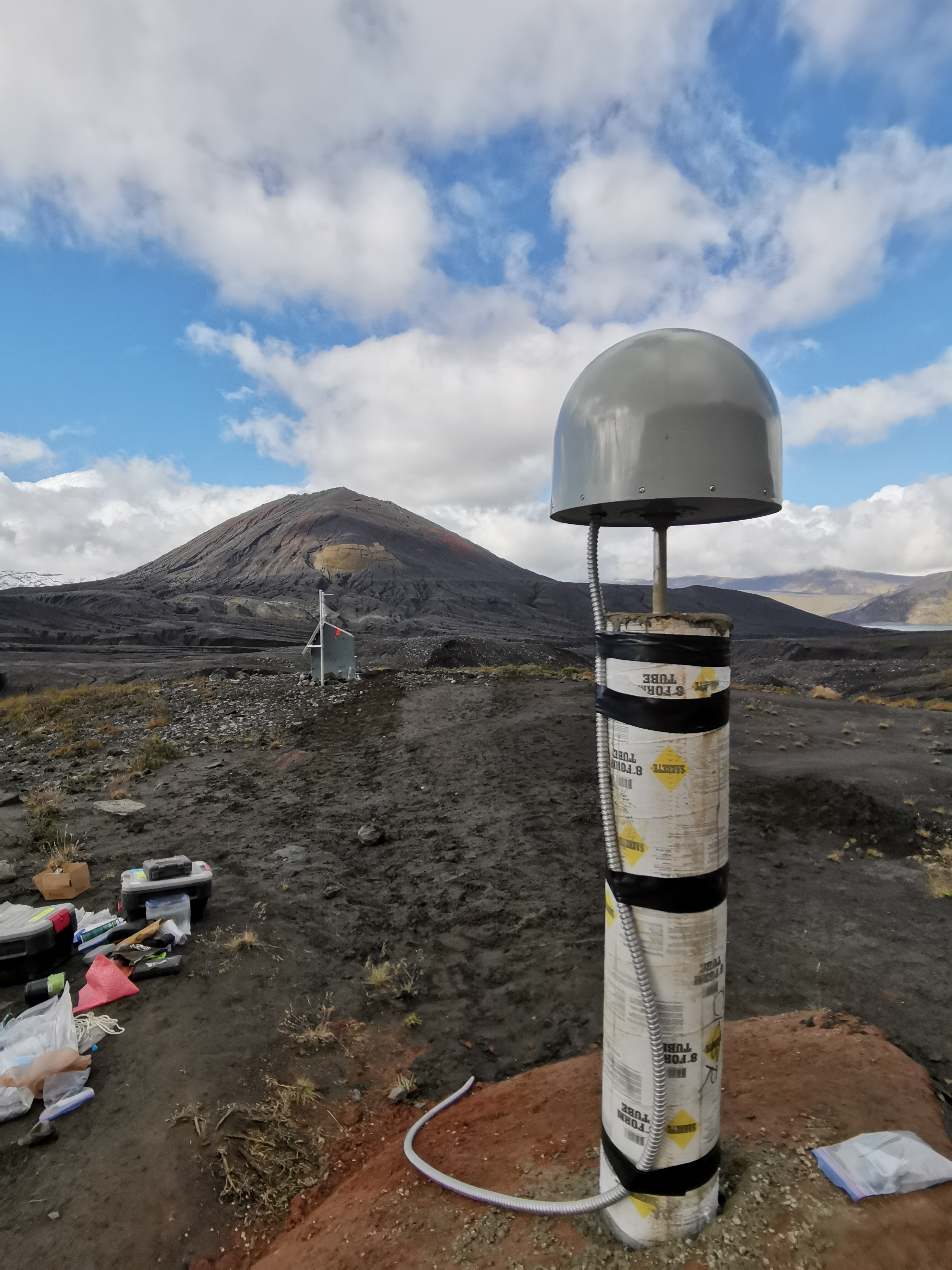
A GNSS measurement site typically consists of a ground receiver and one or more antennas that are anchored to a stable platform. There exist a number of means by which such a stable platform is created, such as:
- Steel rods epoxied into holes drilled directly into solid bedrock (ideally) or otherwise some large, stable rock
- Concrete pillars fixed to solid bedrock (ideally) or otherwise some large, stable rock
- Steel rods driven deep into some consolidated but non-bedrock ground
- Small survey monuments afixed in solid bedrock, which can be used to make campaign (non-continuous) measurements
These antennas are typically mounted in a way that allows them to track the sky and receive signals from a wide range of satellites. The receiver processes the signals from the satellites and uses them to determine the precise location of the station. In addition to the necessary power system, a station may also include additional equipment, such as a radio or cellular modem for transmitting data, or a computer for storing and processing data locally. In order to ensure the highest possible accuracy, GNSS stations are often calibrated and checked against known reference points, and they are typically operated by trained professionals who are familiar with the equipment and techniques used in geodetic surveying.
Volcanic deformation
Geodesy is an important field in the study of volcanoes, as it provides scientists with a means of accurately measuring and monitoring changes in the shape of a volcano, as well as movements of the Earth's crust that can be associated with volcanic activity. For example, satellite radar interferometry can be used to measure very small changes in the height of a volcano, which can indicate the presence of magma moving beneath the surface. GNSS can be used to track the movement of a volcano over time, which can provide important information about the direction and speed of magma movement. Additionally, ground-based strain meters can be used to measure deformation of the ground surface near a volcano, which can provide early warning of an impending eruption.
Limitations
While GNSS is a very accurate and powerful tool for geodesy, there are a few potential limitations and weaknesses to consider. For example, GNSS measurements are subject to errors caused by the ionosphere and the troposphere, which are layers of the Earth's atmosphere that can affect the propagation of GNSS signals. Additionally, GNSS systems are operated by different countries and agencies, and there can be differences in the accuracy and reliability of the signals from different systems.
References
Herring, T. (Ed.). (2010). Treatise on Geophysics, Volume 3: Geodesy. Elsevier.
The Global Positioning System. GPS. (n.d.). Retrieved December 29, 2022, from https://www.gps.gov/