Imagery
Background
Monitoring volcanoes with cameras
A picture can tell us a lot about a volcano. So much so that, in recent years, an ever increasing number of cameras have been pointed at eruptions—such as that of Fagradalsfjall, Iceland, in 2021—and beamed around the world for all to see. At any given time over the 6 months of the 2021 Fagradalsfjall eruption, channels live-streaming footage from Fagradalsfjall 24 hours a day had thousands of viewers. The public, monitoring agencies, and researchers alike were tuned in to watch fresh lava fountaining, oozing, and exploding out of the ground.
Besides the awe-inspiring visual experience provided by eruptions, the presence of ash, gas plumes, incandescence, and visual sighting of lava flows can all provide a wealth of information into the state of an ongoing eruption, which may not be apparent from other streams of data, such as seismicity and deformation. Monitoring agencies use this information during the course of their typical eruption—pre-, during, and post-—assessments to try better understand the potential hazards to the public. In addition, once in place, these devices enable safe, remote monitoring of activity, which is critical for the ongoing safety of the public and those tasked with monitoring, alike. Think 'spider legs' from Dante's Peak, if a little more static (and somewhat more reliable!).
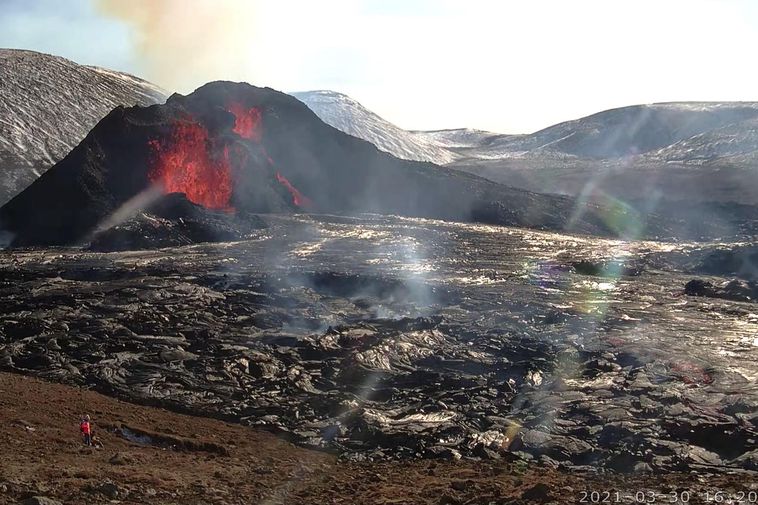
A still from one of a number of webcams deployed around the Fagradalsfjall eruption site, Iceland, in 2021. Webcam operated by mbl.is.
Along with this wealth of imagery data has come a raft of research seeking to better understand eruption processes. For example, 2 cameras can be used in stereo to re-construct 3-D estimates of plume volumes, which can in turn provide improved forecasting of the potential for heightened concentrations of potentially harmful volcanic gases. Other research has sought to derive knowledge of the dynamics and properties of lava flows from time-lapse and video data, which can fed forward into future lava flow models that are used to forecast threats to the local population and infrastructure. In time, with more imagery data readily available, this field of research will play a pivotal role in eruption monitoring and even potentially forecasting.
AVERT webcams
Our instruments
The camera at the CLNE site on Cleveland is a StarDot Technologies NetCam SC H.264, capable of capturing up to 1.3 Megapixel JPEG images. For more information, please see the StarDot Technologies webpage. Camera metadata can be retrieved from our data API—please see the relevant documentation for more information.
Example images from the field
The following images show the view of the summit and plume of Cleveland volcano.
The view of the summit and plume of Cleveland from the CLNE site.
The view of the summit and plume of Cleveland from the CLCL site, situated on nearby Carlisle volcano.
Data access
Images captured by cameras directed towards our target volcanoes (currently Cleveland and Okmok, in the Aleutians) are available for browsing and download through our web archive browser, or can be downloaded via our data API using a command line tool, such as cURL, or the Python requests library. Full documentation of the data API is available here, and an example of how to use request data via the API is shown below:
    import requests


    # First, specify our search criteria
    site = "CLNE"
    vnum = 311240
    search_from = "2022-10-01T00:00"
    search_to = "2022-10-02T00:00"

    # Next, construct a database query for images matching these criteria
    base_uri = "https://avert.ldeo.columbia.edu/api/imagery/visible"
    query = (
        f"{base_uri}/query?"
        f"site={site}&vnum={vnum}"
        f"&search_from={search_from}&search_to={search_to}"
    )

    # Submit these query as a GET request to the data API using requests
    response = requests.get(url=query)

    # If the query returns fewer than 100 results, these can be downloaded
    # as a zipped folder directly
    if len(response.json()) <= 100:
        _ = requests.get(url=f"{query}?download=true")

    # Otherwise, loop over each image and request them from the dedicated
    # single image request API endpoint
    for image in response.json():
        print(f"Downloading image:\n\t{image['image_id']}")
        _ = requests.get(
            url=f"{base_uri}/r/{image['image_id']}?download=true"
        )
Data attribution
Images from the camera deployed at CLNE are archived at the Lamont-Doherty Earth Observatory, and can be accessed through our web API. All other camera images available through our portal for the Alaska project are mirrored from the Alaska Volcano Observatory web portal. These cameras were installed and are actively maintained by the Alaska Volcano Observatory.